 FEAMP GeoNetwork catalogue
Format of the resource (e.g. *.shp)
Type of resources
Topics
INSPIRE themes
Keywords
Contact for the resource
Provided by
Years
Formats
Representation types
Update frequencies
status
-

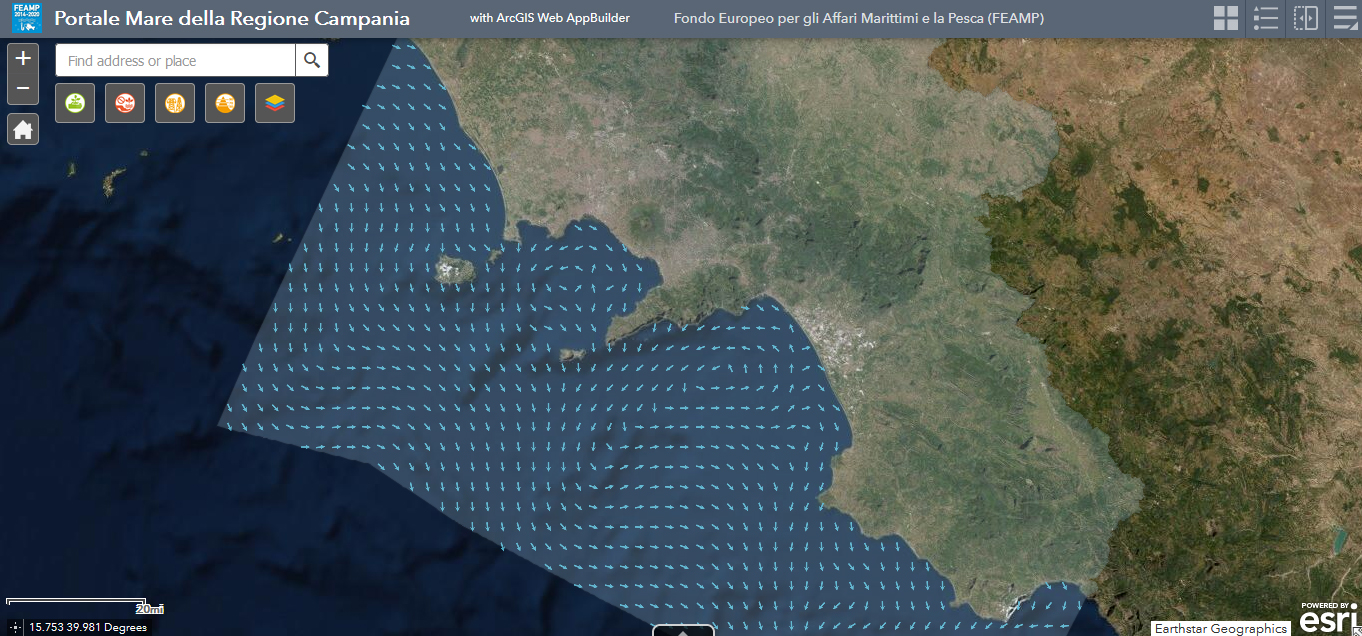
The physical component of the Mediterranean Forecasting System (Med-Currents) is a coupled hydrodynamic-wave model implemented over the whole Mediterranean Basin including tides. The model horizontal grid resolution is 1/24˚ (ca. 4 km) and has 141 unevenly spaced vertical levels.The hydrodynamics are supplied by the Nucleous for European Modelling of the Ocean (NEMO v3.6) while the wave component is provided by Wave Watch-III; the model solutions are corrected by a variational data assimilation scheme (3DVAR) of temperature and salinity vertical profiles and along track satellite Sea Level Anomaly observations. Product Citation: Please refer to our Technical FAQ for citing products.http://marine.copernicus.eu/faq/cite-cmems-products-cmems-credit/?idpage=169 REFERENCES https://doi.org/10.25423/CMCC/MEDSEA_ANALYSISFORECAST_PHY_006_013_EAS6 Clementi, E., Aydogdu, A., Goglio, A. C., Pistoia, J., Escudier, R., Drudi, M., Grandi, A., Mariani, A., Lyubartsev, V., Lecci, R., Cretí, S., Coppini, G., Masina, S., & Pinardi, N. (2021). Mediterranean Sea Physical Analysis and Forecast (CMEMS MED-Currents, EAS6 system) (Version 1) [Data set]. Copernicus Monitoring Environment Marine Service (CMEMS). Further details: https://resources.marine.copernicus.eu/?option=com_csw&view=details&product_id=MEDSEA_ANALYSISFORECAST_PHY_006_013
-
Wave data, collected by ADCP current meter installed in the Gulf of Naples (Latitude: 40 ° 49.668 'N, Longitude: 014 ° 13.984' E), on a depth of 17.5 m. Data are sampled continuously, every 15 minutes. The parameters acquired are wave height (m), wave period (s), wave direction (degrees) and tide (m).
-

The physical component of the Mediterranean Forecasting System (Med-Currents) is a coupled hydrodynamic-wave model implemented over the whole Mediterranean Basin including tides. The model horizontal grid resolution is 1/24˚ (ca. 4 km) and has 141 unevenly spaced vertical levels.The hydrodynamics are supplied by the Nucleous for European Modelling of the Ocean (NEMO v3.6) while the wave component is provided by Wave Watch-III; the model solutions are corrected by a variational data assimilation scheme (3DVAR) of temperature and salinity vertical profiles and along track satellite Sea Level Anomaly observations. Product Citation: Please refer to our Technical FAQ for citing products.http://marine.copernicus.eu/faq/cite-cmems-products-cmems-credit/?idpage=169 REFERENCES https://doi.org/10.25423/CMCC/MEDSEA_ANALYSISFORECAST_PHY_006_013_EAS6 Clementi, E., Aydogdu, A., Goglio, A. C., Pistoia, J., Escudier, R., Drudi, M., Grandi, A., Mariani, A., Lyubartsev, V., Lecci, R., Cretí, S., Coppini, G., Masina, S., & Pinardi, N. (2021). Mediterranean Sea Physical Analysis and Forecast (CMEMS MED-Currents, EAS6 system) (Version 1) [Data set]. Copernicus Monitoring Environment Marine Service (CMEMS). Further details: https://resources.marine.copernicus.eu/?option=com_csw&view=details&product_id=MEDSEA_ANALYSISFORECAST_PHY_006_013
-
Current meter data, collected by ADCP current meter installed in the Gulf of Naples (Latitude: 40 ° 49.668 'N, Longitude: 014 ° 13.984' E), on a depth of 17.5 m. Data are sampled continuously, every hour (mean). The parameters obtained are current direction (degrees) and current velocity (m / s) on 49 cells of 50cm. Not all 49 cells are in the water, the reference cell for the surface is bin 30.
-

The physical component of the Mediterranean Forecasting System (Med-Currents) is a coupled hydrodynamic-wave model implemented over the whole Mediterranean Basin including tides. The model horizontal grid resolution is 1/24˚ (ca. 4 km) and has 141 unevenly spaced vertical levels.The hydrodynamics are supplied by the Nucleous for European Modelling of the Ocean (NEMO v3.6) while the wave component is provided by Wave Watch-III; the model solutions are corrected by a variational data assimilation scheme (3DVAR) of temperature and salinity vertical profiles and along track satellite Sea Level Anomaly observations. Product Citation: Please refer to our Technical FAQ for citing products.http://marine.copernicus.eu/faq/cite-cmems-products-cmems-credit/?idpage=169 REFERENCES https://doi.org/10.25423/CMCC/MEDSEA_ANALYSISFORECAST_PHY_006_013_EAS6 Clementi, E., Aydogdu, A., Goglio, A. C., Pistoia, J., Escudier, R., Drudi, M., Grandi, A., Mariani, A., Lyubartsev, V., Lecci, R., Cretí, S., Coppini, G., Masina, S., & Pinardi, N. (2021). Mediterranean Sea Physical Analysis and Forecast (CMEMS MED-Currents, EAS6 system) (Version 1) [Data set]. Copernicus Monitoring Environment Marine Service (CMEMS). Further details: https://resources.marine.copernicus.eu/?option=com_csw&view=details&product_id=MEDSEA_ANALYSISFORECAST_PHY_006_013
-
Wave data, collected by ADCP current meter installed in the Gulf of Naples (Latitude: 40 ° 49.668 'N, Longitude: 014 ° 13.984' E), on a depth of 17.5 m. Data are sampled continuously, every 15 minutes. The parameters acquired are wave height (m), wave period (s), wave direction (degrees) and tide (m).
-

Current meter data, collected by ADCP current meter installed in the Gulf of Naples (Latitude: 40 ° 49.668 'N, Longitude: 014 ° 13.984' E), on a depth of 17.5 m. Data are sampled continuously, every hour (mean). The parameters obtained are current direction (degrees) and current velocity (m / s) on 49 cells of 50cm. Not all 49 cells are in the water, the reference cell for the surface is bin 30.
-
The physical component of the Mediterranean Forecasting System (Med-Currents) is a coupled hydrodynamic-wave model implemented over the whole Mediterranean Basin including tides. The model horizontal grid resolution is 1/24˚ (ca. 4 km) and has 141 unevenly spaced vertical levels.The hydrodynamics are supplied by the Nucleous for European Modelling of the Ocean (NEMO v3.6) while the wave component is provided by Wave Watch-III; the model solutions are corrected by a variational data assimilation scheme (3DVAR) of temperature and salinity vertical profiles and along track satellite Sea Level Anomaly observations. Product Citation: Please refer to our Technical FAQ for citing products.http://marine.copernicus.eu/faq/cite-cmems-products-cmems-credit/?idpage=169 REFERENCES https://doi.org/10.25423/CMCC/MEDSEA_ANALYSISFORECAST_PHY_006_013_EAS6 Clementi, E., Aydogdu, A., Goglio, A. C., Pistoia, J., Escudier, R., Drudi, M., Grandi, A., Mariani, A., Lyubartsev, V., Lecci, R., Cretí, S., Coppini, G., Masina, S., & Pinardi, N. (2021). Mediterranean Sea Physical Analysis and Forecast (CMEMS MED-Currents, EAS6 system) (Version 1) [Data set]. Copernicus Monitoring Environment Marine Service (CMEMS). Further details: https://resources.marine.copernicus.eu/?option=com_csw&view=details&product_id=MEDSEA_ANALYSISFORECAST_PHY_006_013